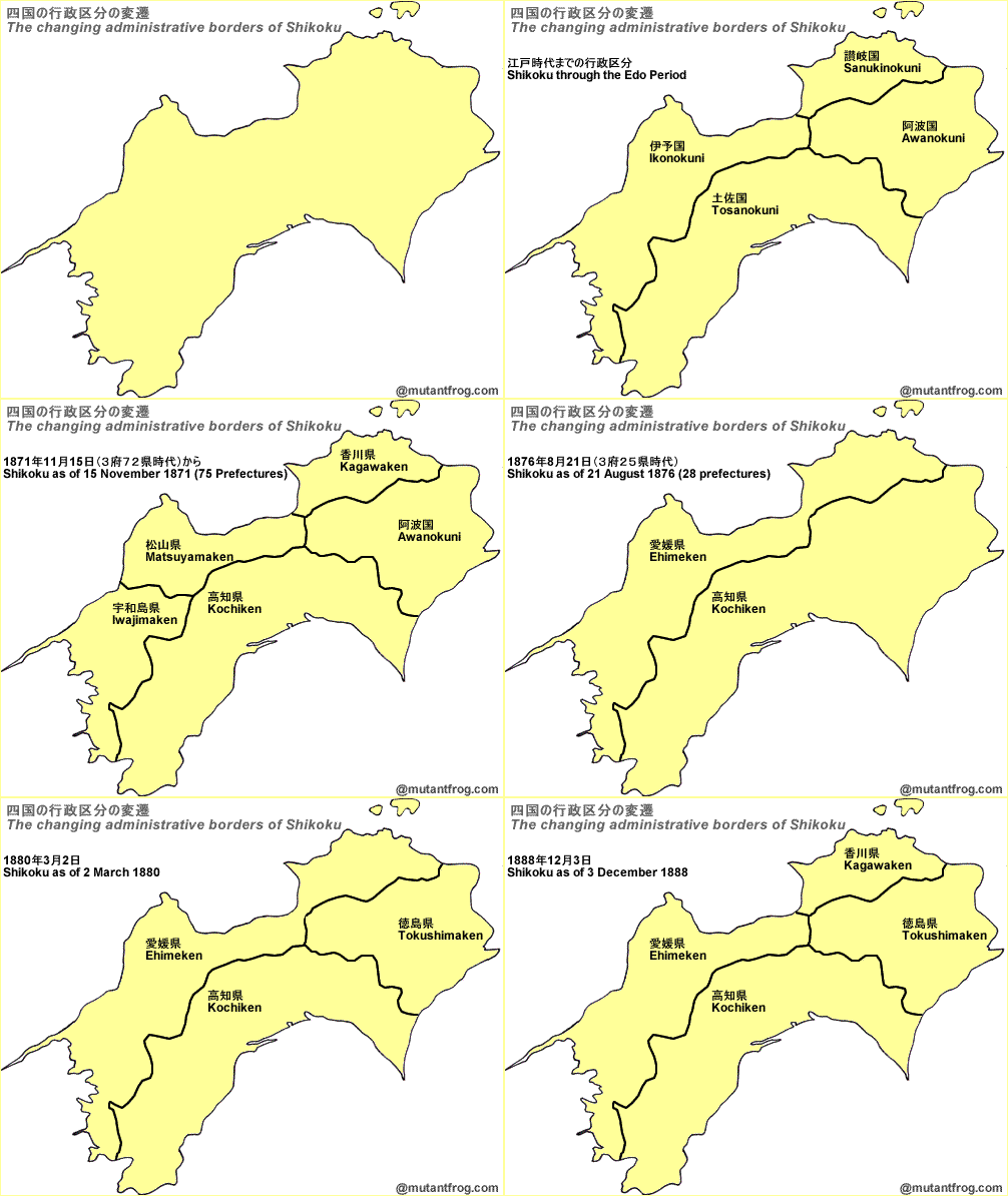
At ComingAnarchy, I’ve spent years publishing posts that show, through simple graphic animation, the changing borders of nations over the course of human history. Japan as a nation is not a very exciting topic–the borders have stayed pretty much the same, except for the brief imperial period a century ago, at least internationally. Domestically and internally, there has been much change through the years, that may be too much of a Japan-centric topic for ComingAnarchy, but which may interest MF readers.
For the first of what I hope will be several examples, let’s look at Shikoku at the end of the 19th century. I was recently reading 日本全国「県境」の謎 (The mysteries of Japan’s prefectural borders) by Kenji Asai, who has written dozens of books on Japan’s regional geography. I was amused by the sudden changes that took place in the administrative divisions of Shikoku in less than two decades. Shikoku, which means “four countries”, and went from four “countries” during the Edo Period, to five prefectures, then three, then two, then three again, and finally back to four. The transition goes like this:

See the ComingAnarchy Changing Borders Series:Ethiopia – Poland – Armenia – Persia – Russia I – Russia II – Russia III – India – Britannia – Sweden – Saudi Arabia – Vietnam

Nice video, but you’ve got a couple of typos in there — should be Iyonokuni for 伊予の国 and Uwajimaken for 宇和島県.
The animated GIF is cute, but I’d rather see side by side photos, or “layered” photos to better compare the differences. Not having control over the animation is a little frustrating.
So why were there so many changes in such a short period of time? Bureaucratic strife in the Meiji court?
This is an interesting topic, and I would have liked to see some history explaining why these changes were made. I have to say, though, the typos in the GIF are really sloppy.
Joe, it’s not really clear. I wish I knew more about the bigger picture. I think Japan was trying to figure out how it handled its local government, as the Meiji Era did see a revolution in draining power from the local provinces and centralizing it with the central government — something that hadn’t happened before, despite the Edo Period concentration of power where the Shogun sat and balanced and played off the local lords against each other.
From what I understand, the delineation of prefectural borders was actually a rather hit-and-miss ad hoc affair as they didn’t really know what they wanted. Not so much strife as testing a new government system. In general, they followed the old han, but often they were initially broken into the old kuni if those were smaller than the han, like in the Hokuriku, which went through a very similar muddle as Shikoku, only more so – starting out with three large ones and two very small ones from memory, then consolidating them to eventually arrive with one super-ken (Ishikawa) that covered all of Toyama, Ishikawa, and northern Fukui, before that was split up into the modern borders (Toyama, at least, was most unhappy at *still* being ruled from Kanazawa and wanted freedom, and there was also a big disagreement about what to spend money on: Kanazawa roads or Toyama water control. See “Becoming Apart: National Power and Local Politics in Toyama, 1868-1945” (Michael Lewis) for details).
What bugs me the most about the modern prefectures, however, is that some unimaginative gummint plodder decided that in general they should all have the same name as their capital. So gone are Shinano, Kaga, Owari, Sagami, and the like, and now we need to keep being precise about whether we mean Niigata City or Niigata Prefecture. Okay, some of them would not work well, when more than one kuni was joined, but my point still stands.
Lots of argument over who gets the prefectural capital when two separate han joined too, I understand.